By Jason Konigsberg
Snow coverage in Colorado was fairly evenly distributed by the end of January. All Colorado river basins were at or above 100% of the normal median for Snow Water Equivalent (SWE). This changed in February. Persistent northwest flow brought consistent snowfall to the Northern Mountains and parts of the Central Mountains. SWE increases during February were 200% of the normal median for numerous Snotel sites in the Northern Mountains. The Sangre de Cristo range and Red Mountain Pass stayed close to 100% of monthly SWE increases while other areas of the Southern Mountains saw a very dry month.
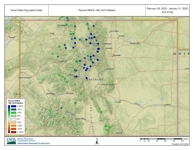
This image shows accumulated SWE in February as a percentage of the median SWE increase in February from 1981 to 2010. The blue dots show Snotel sites with an increase in SWE of 200% or more. The dark green dots show increases near 100% of normal median, and light green dots show increases closer to 50%. Image courtesy of the National Resources Conservation Service.
The CAIC recorded 862 avalanches during the month, 122 of which were triggered by people. Eleven people were caught in avalanches, three partially buried, and tragically two people were fully buried and killed.
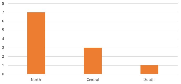
The number of people caught in avalanches during February of 2020 in each region of Colorado.
The first few days of February started warm and dry. The avalanche danger was Moderate (Level 2 of 5) in all ten zones on February 1 and the primary avalanche concern was triggering a small to large Persistent Slab avalanche. February 2 was the warmest day of the month and many mountain locations saw temperatures break the 40 F mark. Fremont Pass (11,400 ft) recorded a high temperature of 43 F. Schofield Pass (10,701 ft) a high of 47 F and Wolf Creek Pass (11,800 ft) a high temperature of 36 F. As temperatures subsequently cooled off, a crust formed on east through south-facing slopes. Plummeting temperatures on February 4 and 5 quickly faceted the snow around this crust. This crust-facet combination would become a major problem with additional loading.
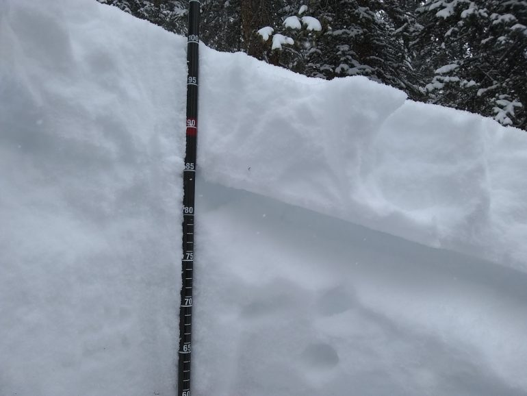
A snowpit on a southeast-facing slope in the Sawatch zone shows a weak upper-snowpack structure on February 6, 2020.
The next loading event started on February 6. An Atmospheric River riding over a high-pressure system in the Pacific took aim at Colorado. The CAIC issued an Avalanche Warning for six zones in the Northern and Central Mountains on February 6, which continued through February 8. A period of intense snowfall began on February 6 and lasted through the evening of February 7. The northwesterly storm track favored the Northern Mountains and parts of the Central Mountains. This storm was one of the most intense 48-hour periods in recent memory. The Columbine Snotel, on Rabbit Ears Pass, recorded a 2.9” increase in SWE in 24 hours. This was the biggest 24 hour SWE increase at this Snotel since the site was installed in 1986. Other notable SWE increases included Copper Mountain and Independence Pass Snotels with a three-day increase of 2.6” and 2.5” respectively. These 3-day numbers were also a Snotel data record. Although this storm largely missed most of the Southern Mountains, portions of the North San Juan zone still picked up healthy snow amounts. Storm totals for Red Mountain Pass were about 2 inches of SWE, around 3 feet of snow.
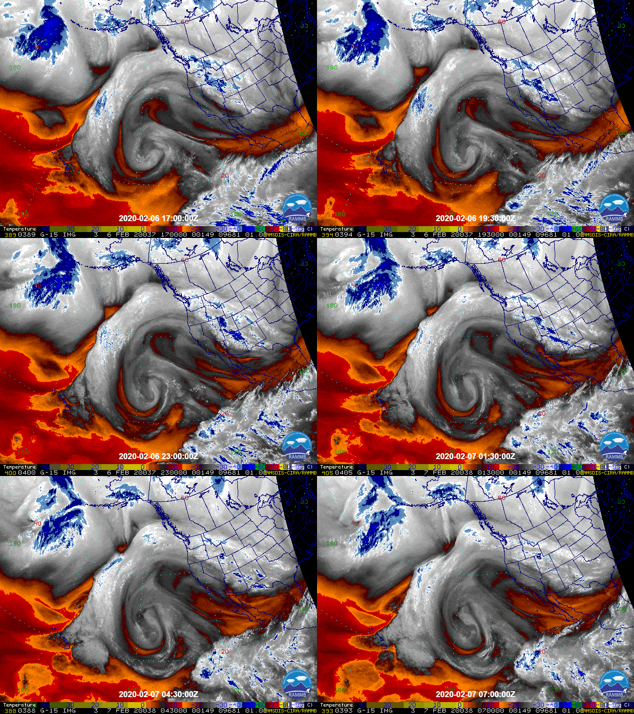
Mid-level, water vapor, satellite image on February 6, 2020. This loop shows the stream of deep moisture funneling into Colorado on northwest flow.
As expected, we saw numerous avalanches during the storm associated with periods of high-precipitation intensity. As the storm cleared on February 8, it seemed that a lot of the evidence of natural avalanches was filled in by winds, obscuring the true extent of this avalanche cycle. Slopes that did not avalanche were left with a new and strong slab of snow resting on old weak layers. In some cases the 2 to 4 feet thick slab lay above both the weak layer that formed in early February and basal facets, or depth hoar, from October. Following the storm numerous avalanches broke on these weak layers in the Northern Mountains and the Sawatch and Gunnison zones.
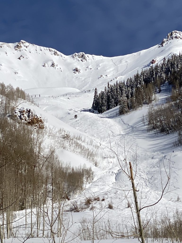
Although the February 6 and 7 storm was more widespread in the Northern Mountains, the northern San Juan Mountains also also saw good snowfall, wind, and significant avalanche activity. Pictured is a southeast-facing slope on February 8 near Ophir.
CDOT mitigation efforts along I-70 and near Berthoud Pass on February 11 triggered a large avalanche in the Widow Maker slide path near Arapahoe Basin that buried US-6. Mitigation work also triggered another large avalanche in the Campground slide path near Berthoud Pass. This slide path put avalanche debris on US-40 for the first time since 1950. On February 13 CAIC and CDOT conducted helicopter mitigation work in Tenmile Canyon. Numerous large avalanches ran with powder clouds dusting I-70.
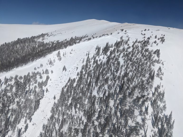
An avalanche triggered by heli-bombing above US-40 on February 11, 2020.
Northwest flow continued to generate snow through the middle of February for the northern half of Colorado. Consistent snowfall and several strong wind events led to spikes in avalanche activity. One of the most notable events occurred around February 14, causing another uptick in avalanche activity.
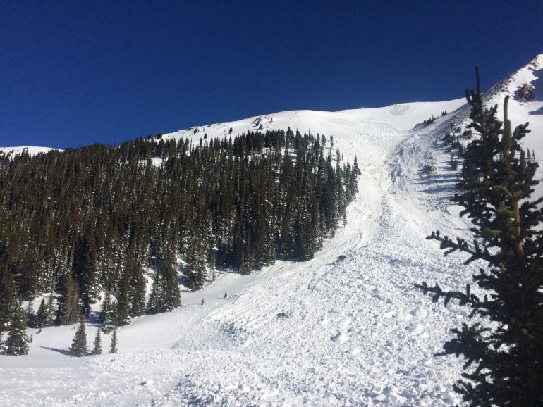
A very large natural avalanche on a southwest-facing slope in Herman Gulch in the Front Range. Photo taken on February 14,2020.
On February 15 , three motorized snowbikers north of Vail triggered a hard slab avalanche. All three riders were caught in the avalanche and two were fully buried and killed. This was the third and fourth avalanche fatality in Colorado this season. The avalanche likely failed on an old layer of faceted snow about three feet below the surface. This was most likely the weak layer that formed in early February during warm weather followed by very cold temperatures.
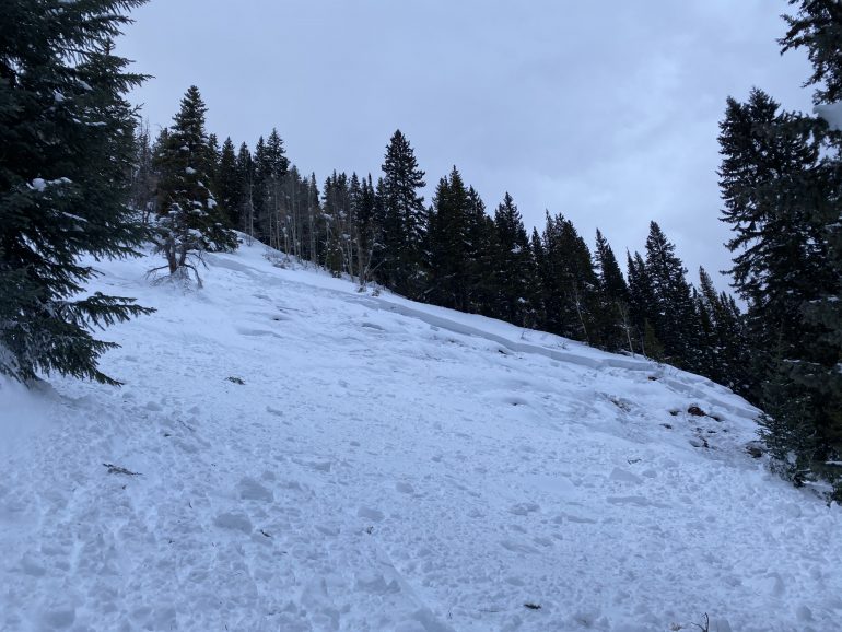
Looking up at the northern part of the fatal avalanche near Vail on February 15. Image courtesy of Hunter Schleper.
Another round of snow hit the Northern Mountains and parts of the Central Mountains on February 23 and 24. An intense band of snow set up in a line from Leadville to Breckenridge on the morning of the 23. Areas underneath this band saw 2 inch-per-hour snowfall rates with 8 to 10 inches in 5 hours. There wasn’t much wind during the snowfall and although the snow fell fast and furious, few avalanches were reported. This changed overnight on the 24 as wind increased dramatically from the northwest. The intense loading resulted in numerous natural avalanches. The most widespread activity was noted in the Sawatch Range but the largest and most notable avalanches were observed near Peak 1 in the Tenmile Range. The Peak 1 avalanche looked to be the largest avalanche in Colorado this season.
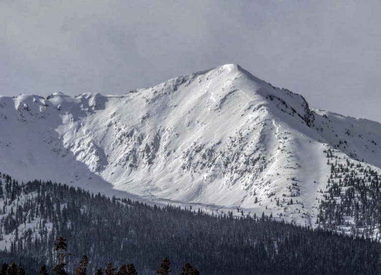
This very large avalanche on the southeast face of Peak 1 in the Tenmile Range released during a wind-loading event around Monday, February 24.

The number of naturally triggered avalanches, size D2 and larger, in the three mountain regions of Colorado from February 9 to 23, 2020. Avalanche activity continued for several days following a large snowstorm on February 6 to 7, 2020.
For the month of February, the Steamboat and Flat Tops zone had a lower avalanche danger than the other forecast zones in the Northern Mountains. The Steamboat and Flat Tops zone had a deeper and stronger snowpack at the start of the month. The early February storm produced abundant snowfall across the zone, but with a strong snowpack most of the avalanches were small. There were no reports of avalanches breaking on deeper weak layers during the storm or for the rest of the month. The CAIC rated the avalanche danger as Low (Level 1 of 5) for eleven days during the month. Increases in the danger were caused by precipitation and wind events, and associated new snow avalanche problems.
February was an active month for avalanches in the rest of the Northern Mountains and part of the Central Mountains. The Front Range, Vail and Summit County, Sawatch and Gunnison zones had similar avalanche danger ratings and avalanche problems most of the month.
Although the avalanche danger ratings in the Aspen zone were similar to the more active zones, there was much less avalanche activity. The number of avalanches reported decreased faster than in adjacent zones after the big February storm, and the last large avalanche in the Aspen zone was on February 8.
In the Southern Mountains, the avalanche danger was generally lower in February than it was in January. The San Juan Mountain zones went to Low danger for the first time this season on February 2. For the month, the North San Juan zone and the South San Juan zone were at Low danger 9 and 12 days respectively. Any days of higher danger were associated with small snowfall amounts coupled with wind-drifting, sometimes activating shallowly buried weak layers.
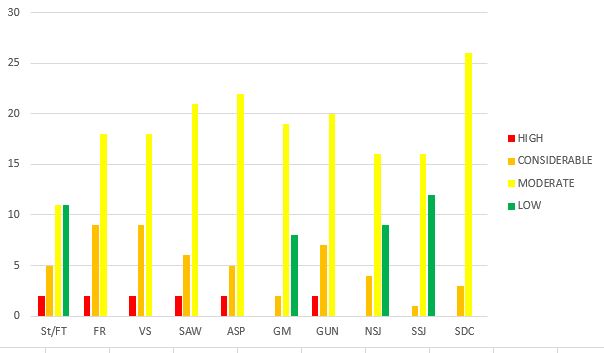
The backcountry avalanche danger rating for each zone in Colorado during February 2020.
By the end of February the water content of the snowpack was above or near the normal median for most areas. The southwest corner of the state dropped below the long term median. In the deeper snowpack areas, weak layers improved and there were no reports of avalanches breaking near the ground for the last four days of February. The Southern Mountains ended the month with a shallower and weaker snowpack than on February 1. Although sunny slopes were beginning to transition to a springtime regime, the snowpack on shady slopes lost strength.
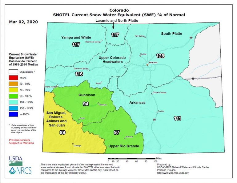
SWE percent of normal for river basins in Colorado. Image courtesy of the National Resources Conservation Service.
